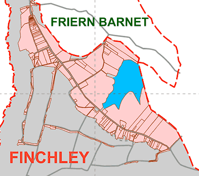
 East Finchley is a part of a not very significant place. You can tell that
from the shape of it. Finchley started off as an appendage of the Bishop of
London's Fulham estate. It was then administered as part of Hornsey. Late in
the day it gained independence fleetingly first as an Urban District, then a
Borough before losing out to become part of the London Borough of Barnet. Finchley
itself was composed of several settlements and to this day most people in East
Finchley are proud to belong to that small community.
East Finchley is a part of a not very significant place. You can tell that
from the shape of it. Finchley started off as an appendage of the Bishop of
London's Fulham estate. It was then administered as part of Hornsey. Late in
the day it gained independence fleetingly first as an Urban District, then a
Borough before losing out to become part of the London Borough of Barnet. Finchley
itself was composed of several settlements and to this day most people in East
Finchley are proud to belong to that small community.
Below is my history of the area. This account started as a history series for the local newspaper, The Archer. I have also attached to this page copies of one or two talks I have given on local history. Most of the historical photos on this site are courtesy of the Finchley Society. Sources of information are given at the bottom of the page. See also some nuggets of local history collected here.
A detailed authoritative source is the Victoria History of the County of Middlesex Volume 6 available on line
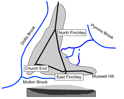 The
unique terrain of Finchley owes much to the Anglian Ice Age, which pushed south
about half a million years ago, stopping just a little to the south of us.
The
unique terrain of Finchley owes much to the Anglian Ice Age, which pushed south
about half a million years ago, stopping just a little to the south of us.
It is best explained in conjunction with the British Geological Survey Map. Opening the map your attention is caught by a light blue triangle, the Finchley triangle, sitting in the midst of the surrounding brown clay. Fortis Green, East End Road and Ballards Lane run along southern and north western sides of this triangle at a fairly regular height of 90 to 95 metres but the triangle dips down toward the north east, to where the High Roads of East and North Finchley meet the North Circular Road.
The light blue represents a unique surface layer of chalky, sandy clay, pushed down from the north and deposited when the icecap melted. Under this clay, in a hollow in the base clay of the region, lies a “filling” of Dollis Hill gravel, probably deposited by a major tributary flowing north to join the Thames, then flowing through Watford. The ice cap blocked these northern routes, forming enormous lakes, and diverted the Thames, originally flowing north-west to the Wash, through London on its current course.
The gravel “filling” has acted as a reservoir ever since, excess rain water flowing over the join between gravel and clay in numerous streams, noticeably to the north east, to join Pymm’s Brook and the River Lea. The steep southern and north western sides drain westward, the Dollis Brook and Mutton Brook joining to form the Brent Brook which flows backward along the earlier river course.
The topography of this triangle has played a key part in the history and development of Finchley as a whole. When settlements first started to appear, the clayey and patchy nature of the ground led to distributed settlements, the well drained south and west slopes being especially favoured.
Acknowledgements: British Geological Survey, London & The Thames Valley, 1996 edition.
 An
attractive feature of East Finchley today is its closeness to woodland, remnants
of a much earlier extensive covering.
An
attractive feature of East Finchley today is its closeness to woodland, remnants
of a much earlier extensive covering.
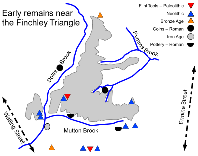
Following the retreat of the icecap the Finchley triangle was re-colonised by
plants, animals and finally man. Early man would have found the area forested
and difficult and there is nothing to suggest any clearing might have taken
place before 5000 BCE.
Early travellers left evidence of passage, from early stone age flint tools in the centre of the triangle, to late stone age flints around Muswell Hill but there is no evidence of any settlement. The Romans visited the area too, leaving coins and pottery quite close by.
The Romans usually avoided the hilly northern heights, constructing straight roads in the valleys either side, Watling Street and Ermine Street, known today as the Edgware Road and Tottenham High Road. Even when the Romans left, the roads they left behind remained in use and most people had very little reason to venture into the woods covering Finchley. The nearest track way was probably the early route of Hampstead Lane, before it was diverted away from Kenwood House, and which formed Finchley’s southernmost boundary.
Then came the Saxons up the River Thames to settle in its valleys. These middle Saxons were a loose group of tribes, dominated in turn by the Kingdoms of Essex, Mercia and Wessex. The name Finchley - clearing with finches - owes its name to them. King Alfred’s son Edward introduced the counties of Middlesex and Hertfordshire about 900 CE as a defence against the Danes, and the middle Saxons were divided between them; the area now known as Finchley forming the northern border of Middlesex.
The county was later divided into 7 or 8 administrative units known as “Hundreds” and Finchley was in the Hundred of Ossulstone, centred on London and with its court near Speakers Corner, marked by Oswald’s stone. The Dollis Brook formed the boundary between the hundred of Ossulstone and the neighbouring hundred of Gore
Acknowledgements: The Westminster Corridor, David Sullivan, 1994
 The
Bishops Avenue and The Bishops Wood are the last reminders of the Bishops of
London, Finchley’s remote landlords for almost one thousand years.
The
Bishops Avenue and The Bishops Wood are the last reminders of the Bishops of
London, Finchley’s remote landlords for almost one thousand years.
It was King Ethelbert of Kent, having married a French Christian in around
600, who set about reconverting Britain. After installing Augustine in Canterbury
he set up an enormous diocese of St Paul in London, based on his reluctant nephew’s
Essex kingdom. To fund its activities he endowed it with the estate of Stepney.
A hundred years later, after initial setbacks, Fulham was added.
The impenetrable northern heights belonged to these estates, Finchley to Fulham
and Hornsey to Stepney. As such they do not get specific mention in the Domesday
Book. Their boundaries were determined by the boundaries of more important neighbouring
estates - Hendon, Hampstead, Tottenhall and so on. They were based on landmarks
such as the Dollis and Mutton Brooks, and the ancient track just south of the
present Hampstead Lane.
Travellers northward from Finchley enter Hertfordshire and then re-enter Middlesex. This is because the land of the upper Pymms Brook, down as far as Bettstyle (the blue circle), was given to the monks of St Albans before the administrative boundaries were defined.
Because the Bishops owned both Finchley and Hornsey, the shared boundary wasn’t formalised until 1738.
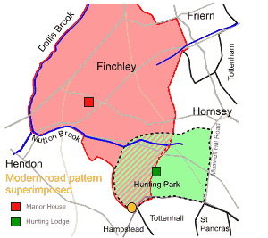
By the 1200’s the Bishops had established a hunting park of 1070 acres across the south of this combined property, with access from the south, stretching from the present day Spaniards in the west, to Highgate Gatehouse in the east and East Finchley to the north, with gates at these extremities. Turners Wood, Bishops Wood and Highgate Wood are vestiges of this park, which was bordered by a ditch and hedge to keep the deer in (park of this hedge is thought to remain in the corner of Lyttleton Playing Fields) and there was a hunting lodge (marked on the map by a green rectangle), visited by kings, in the centre. The Hunting Park, sometimes known as Hornsey Park) ceased to be used as such in the 1500’s, although the moat remaining from the lodge is marked on the 1895 ordnance survey map “Kenwood and Golders Green” .
 Finchley
was firmly on the map by 1199 when King John exempted the Bishop and his tenants
within his domain of Finchley from the payment of various taxes.
Finchley
was firmly on the map by 1199 when King John exempted the Bishop and his tenants
within his domain of Finchley from the payment of various taxes.
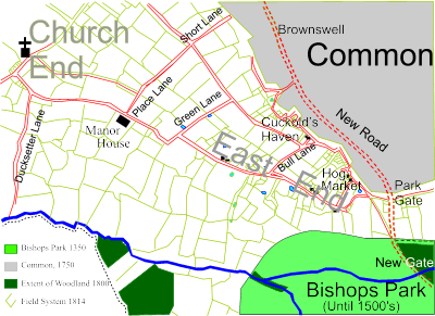
Original access to the heavily wooded Finchley triangle was probably from Hendon, a small settlement originating at the bottom left corner, sufficiently above the Dollis Brook to avoid flooding. At some time the church was built.
Originally the dense woodland on clay soil yielded wood products - timber and charcoal - and foraging for pigs. As the area was cleared eastwards from this settlement early routes hugging the two main sides of the Finchley triangle. Cleared land yielded to grazing sheep and hay production.
To administer the land a manor house was built, part way between the original settlement, the church end, and the east end, on the high ground hugging route we now call East End Road which linked the easiest and choicest areas for exploitation.
The tenancy of the manor by the wealthy Adam de Basing, Tailor and Chief Financier to Henry III, probably accelerated the clearance. Scattered settlements appeared along East End Road, collectively known as East End. Access to water from the shallow gravel layer allowed many cottages to have their own well. The gravel seams exposed by the south facing slopes of Mutton Brook, would have been attractive for crops. Small settlements grew up along the winding track at the edge of the common, including Cuckolds Haven and Fallow Corner, presumably housing many copy holders, those with rights to make use of the common.
In the 1300’s, the Bishop provided as a business venture, a new toll route though his park, an alternative to the boggy main route to the north along Colney Hatch Lane. It left the park at a new gate, located where the Northern line crosses the High Road today, below the hamlet of Park Gate. The first recorded toll collection was in 1321. Then the road was extended across the Common via Brownswell (by Strawberry Vale), bypassing the East End settlements and rejoining the original route at Whetstone. Now Finchley High Road, this part remained unbuilt on until the Common was developed following enclosure in 1814. The new road improved East End’s opportunities for trade, stimulating the Hog Market and allowing better access to London for the hay and other products. Returning carts carried the soot and manure and gave rise to the “Dirthouse” where the Old White Lion now stands
 For
centuries, Finchley remained an unremarkable rural community whose dependence
on wood based occupations gradually gave way to pasturing, hay making and servicing
the basic needs of London.
For
centuries, Finchley remained an unremarkable rural community whose dependence
on wood based occupations gradually gave way to pasturing, hay making and servicing
the basic needs of London.
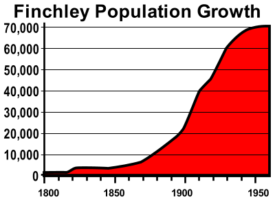
Population never rose much above 250 households at the best
of times. Then, around 1820, several factors coincided which were to change
the face of East Finchley beyond recognition. The enclosure of the common,
the growth and dominance of London, and improvements in transport each contributed
and will be explored in more detail in later chapters. A hint of the change
is just evident on the 1821 Ordnance Survey map which shows the new development
of land around present day Barclays Bank.
London’s growth statistics were phenomenal and fuelled by an influx of
newcomers. In fact, for most of its history, London’s deaths exceeded
its birth rate. Between 1500 and 1650 population increased tenfold, overflowing
boundaries and joining Westminster. By 1700 London surpassed even Paris. Speculative
development between landowner and builder, with the builder taking the risk,
enabled a house building boom which spread across the Euston Road around 1800,
reaching Highgate within 50 years and East Finchley soon after.
The expansion was assisted by the development of the horse drawn omnibus and
the railway (1830’s), horse tram (1870’s), electric tram (1890’s)
and underground (1900’s). The 1860 Cheap Trains Act introduced the cheap
workman’s fare at times outside the normal middle class day and led to
the speculative development of lower cost housing at about the time that East
Finchley became ripe for development. The more affluent classes were always
able to travel that bit faster and further, arriving first, but as areas became
over developed, they moved on, their properties subsequently torn down and replaced
by individually cheaper but much higher density housing. Nowhere is this more
evident than in East Finchley.
 Until the early 1800s the only C of E church in Finchley was the original St
Mary at Finchley almost two miles walk away from the East End community, quite
a hike each week for the inhabitants of East Finchley. A church school was also
set up there in 1813 in response to Methodists introducing teaching at their
chapel.
Until the early 1800s the only C of E church in Finchley was the original St
Mary at Finchley almost two miles walk away from the East End community, quite
a hike each week for the inhabitants of East Finchley. A church school was also
set up there in 1813 in response to Methodists introducing teaching at their
chapel.
History was to repeat itself. The Congregationalists were known to be active in East Finchley by 1804 and by 1830 they had built a chapel on the edge of Finchley common, facing the Great North Road (enlarged in 1846.) In 1842 they started a school, a British school, at the chapel. This draw on their members prompted C of E goers to raise funds for a local church and school in East Finchley, which they did.
Holy Trinity church was built in Bull Lane in 1846, the lane being renamed Church Lane. Holy Trinity School was founded by the parish church in 1847 under the aegis of The National Society for the Education of the Poor in the Principles of the Established Church (thus it was a National school) . It included an “Industrial School”, where pupils were trained in various aspects of agriculture or domestic service. It housed 240 pupils. After a fire at the British School in 1875 the Congregationalists pushed for a school board to take over. This was done in 1881, and as a result their school was replaced by a new board school, in 1884 for 500 boys and girls and 250 infants. Later named Alder School, it became a secondary school, younger pupils being reassigned to a new council school in 1913 renamed Martin School. Meanwhile the Congregationalists had already moved on into a tall graceful church building at the intersection of EER and the High Road until, sadly, now replaced by Viceroy Parade.
The first wave of London expansion to hit EF, in the 1800’s, was to prove short lived. Where elegant houses were to stand in capacious grounds, the memories now live on only in street names.
 The
houses of the affluent normally seek the higher slopes for reasons of health
and aesthetics and EF was no exception. The merits of the south-facing slopes
of the Finchley triangle along East End Road and Fortis Green were noted as
early as 1798 by John Middleton’s Agriculture of Middlesex .. “from
the southeast corner of the common, there is a most enchanting prospect... ..there
are many points in this situation, such as deserve to be adorned with elegant
villas”
The
houses of the affluent normally seek the higher slopes for reasons of health
and aesthetics and EF was no exception. The merits of the south-facing slopes
of the Finchley triangle along East End Road and Fortis Green were noted as
early as 1798 by John Middleton’s Agriculture of Middlesex .. “from
the southeast corner of the common, there is a most enchanting prospect... ..there
are many points in this situation, such as deserve to be adorned with elegant
villas”
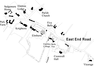
East End Road
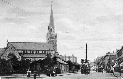
The most notable property, dating from the 1600’s but considerably extended in this period, was Elm House, almost opposite the Five Bells. Its most celebrated occupant was Anthony Salvin, an architect of national renown, whose restorations included Alnwick and Norwich Castles, parts of the Tower, and Thoresby Hall. Salvin and his family were largely responsible for the construction of EF’s parish church of Holy Trinity and the village school on East End Road in the 1840’s.
Elm House, later renamed Elmhurst, survived until the war. Part of the property is now a green space. Another occupant was Samuel Pulham, a Mayor of Finchley, and it his name, rather than Salvin’s which has been remembered. Salvin is remembered indirectly in Springcroft Avenue, as we shall see in a later chapter.
Further along East end Road was Park Farm, later used by George Sanger to winter his circus animals until his murder there in 1911. Between there and Elmhurst was Knightons, opposite Church Lane, and the only surviving building of the period, Fairacres. Between Elmhurst and the Vicarage (Cedar Drive) were some smaller properties and one Cromwell Hall, set back a little down the slope in large grounds.
Fortis Green
 To
my untrained eye, parts of Church Lane and Fortis Green remain the most varied
and attractive parts of the area.
To
my untrained eye, parts of Church Lane and Fortis Green remain the most varied
and attractive parts of the area.
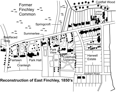
Development of Fortis Green from a countryside track began with the enclosure
of the commons it crossed. The area of Hornsey Common fronting the track was
divided into narrow plots and used to commute the Common’s copyholder’s
rights in 1815. Building started soon after, effectively augmenting the hamlet
of Fortis Green around the Clissold Arms. Meanwhile development from the EF
end began in 1820 when the Bishop sold off a large south facing field on the
Barclay’s Bank corner for development. Known collectively as Park Place
there were four grand houses and numbering from the High Road these were Fairlawn,
Cranleigh, Park Hall and Summerlee respectively. Then, in 1835, just across
the border in Hornsey, architect and EF resident Anthony Salvin and his brother
in law purchased a field and built two elegant Italianate villas Springcroft
and Colethall (later Uplands), the latter being featured in Gardener’s
Magazine at the time. Development of the adjacent plot, behind older houses
on Fortis Green, to be known as the Harwell Estate, began in 1853 and marks
the transition toward the methods which were to be used subsequently for the
development of all EF’s remaining open spaces. The estate was laid out
with roads and divided into small plots for sale in blocks to local builders
for speculative ventures. Starting before the advent of the railway, development
proved slow and piecemeal, which is why this estate has such a wide variety
of architectural styles. At that time, Southern Road went nowhere and even today
you can see the irregular joins at each end. Sometimes several plots were purchased
for one dwelling (see Beechwood); some of the plots in Southern Road have since
been turned round to front Eastern and Western Roads.
The coming of the railway in 1867 increased the pressure for smaller properties,
but that’s another story.
Acknowledgements: The Growth of Muswell Hill by Jack Whitehead.
 Contrary
to popular belief, the Common never belonged to the commoner.
Contrary
to popular belief, the Common never belonged to the commoner.
In Finchley’s case the common was the waste of the Manor of Finchley and as such belonged to the Bishop of London and was regulated by the Bishops Court. Commoners could apply for rights to graze, cut timber or remove earth, or to erect a dwelling in return for a payment, known as a fine. As evidence of their rights, the successful commoners were given a copy of the court roll and were known as copyholders. Nevertheless a gradual unofficial encroachment went on by all and sundry. A common practice was for sheep to be stationed on the common during the hay season and returned to the hayfield after the crop was harvested. Parts of the common were also used in emergencies to “house” those fleeing London during the plague or for exercising troops at times of war.
Land around London gained in value as London expanded, and this made enclosure,
the process whereby the land was parcelled out to individuals, subject to meeting
certain conditions, gradually more desirable.
All interested parties usually had a right to some compensation, whether it
was the allocation of a piece of the land, or the tenure of a dwelling built
on the land of another.
In the case of Finchley Common enclosure was already in progress from 1760
onwards and on 4th April 1811 an act for ‘inclosing land in the Parish
of Finchley’ was introduced into the Commons such that in 1816 (a year
after neighbouring Hornsey) the rest was enclosed.
In the apportionment, 15% of the land went to defray expenses (including to
the Regents Canal Company for a reservoir), the Rector of Finchley then received
13% (in lieu of glebe and tithe), Thomas Allen 11%, the Bishop received 5%,
and the rest was divided proportionately among the freeholders, copyholders,
and lessees. The largest allotments were to John Bacon (10%), the Marquess of
Buckingham (5%), Sir William Curtis (4%), Alexander Murray as lessee of Bibwell
(2.8%), and the Earl of Mansfield as lessee of the demesne woods (2%).
Large parcels of land were subsequently sold off for development of one kind or another, from housing to cemeteries to country estates and had a large impact on the future of East Finchley.
 When
first opening an old map of Finchley I was surprised to see the railway marked
as the “Edgware Line” not the “Barnet Line”. Was this
the mistake it seemed?
When
first opening an old map of Finchley I was surprised to see the railway marked
as the “Edgware Line” not the “Barnet Line”. Was this
the mistake it seemed?
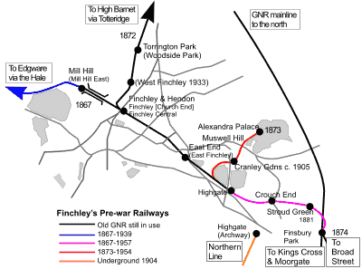
London’s first railway was opened in February 1836, between Deptford
and Bermondsey. Main lines soon followed and the Great Northern Railway opened
into Kings Cross in 1852. The 1850’s and 60’s saw the construction
of most of London’s network of suburban railways, including, in 1867,
the Highgate and Edgware Railway, connecting to the GNR at what is now Finsbury
Park, and subsequently bought up by them. Ongoing trains took commuters on to
Kings Cross and Moorgate.
Double tracks, initially to Highgate, were extended to Finchley, [Church End]
when, in 1872, a double track branch line was added from Church End to High
Barnet. A year later, a further branch was opened from Highgate to serve the
newly constructed Alexandra Palace, with an intermediate station at Muswell
Hill. A shilling return fare from Kings Cross included admission. Within 16
days of opening the palace was burned down with loss of 3 lives, but fortunately
for the railway a second palace opened two years later.
As the surrounding countryside was built over, additional stations were built
at Stroud Green (1881), Cranley Gardens (c.1905), the Hale (1906), and West
Finchley (1933).
Traffic grew and with time the single track to Edgware and the bottle neck into Kings Cross became an embarrassment. From 1874 some services were rerouted into North London Railway’s Broad Street via a connection at Canonbury but the problems persisted. Then came a possible solution to all the line’s problems. In 1933 the Government formed the London Passenger Transport Board with powers and funds for a Londonwide programme of New Works. The proposals included a thorough electrification programme, conversion of the remaining single track from Finchley to Edgware to double, extended to Bushey, and to overcome the bottlenecks, new links to the Underground via Highgate and to Moorgate via the Metropolitan Railway at Finsbury Park. Work started in earnest but then the War intervened.
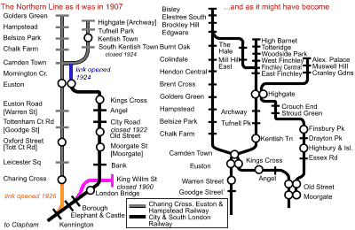 In
1870, London’s first underground tube railway ran under the Thames from
Tower Hill to Pickleherring Street. Driven by cable, it was a technical triumph
but a financial failure.
In
1870, London’s first underground tube railway ran under the Thames from
Tower Hill to Pickleherring Street. Driven by cable, it was a technical triumph
but a financial failure.
In 1883 some plans were revived to build a line from Borough to King William
Street. Eventually, in 1890, this opened from Stockwell to King William Street
as the City & South London Railway after a last minute switch to electric
traction made it the world’s first underground electric tube railway.
[Previous London lines were steam and in tunnels].
This spawned a rush of applications for new lines including the Waterloo &
City [open 1898], the ‘Central’ [open 1900] and the Great Northern
& City [1904], built to relieve the Great Northern’s suburban bottleneck
with a line from Finsbury Park to Moorgate Street. Other schemes were less fortunate
in getting finance until American Charles Tyson Yerkes bought them up and injected
American capital and equipment. One of these was the Charing Cross, Euston and
Hampstead Railway. It had a branch to the Midland railway at Kentish Town -
catchment was everything, the more railways or busy bus routes you could tap
into the greater the chance of success. In 1902 Yerkes successfully applied
for powers to extend the branch to connect with the railway at Highgate while
the Hampstead end was extended to Golders Green, allowing access for a depot
above ground. The other lines would become the Bakerloo and Piccadilly. Yerkes
held these and the tunnel railways (District and Metropolitan District) that
he had purchased for electrification through a holding company, the Underground
Electric Railways of London (UERL). The CCEHR opened on 1907, although the route
north of Archway was not proceeded with.
Meanwhile, in 1901 the C&SLR had been extended north to Angel, rerouting
from Borough to tap into London Bridge Station and eliminate unsatisfactory
gradients at KWS, and thence to Euston in 1907.
When Yerkes acquired the C&SLR (and the ‘Central’ line) in 1913
he planned a junction to the CCE&HR at Camden Town. This involved replacement
of all 22,000 C&SLR tunnel rings by a wider bore to allow the use of standard
rolling stock.
The first through trains ran between Moorgate and Hendon in 1924, although the joint line was not called “Northern” until 1937.
The link under the Thames from Charing Cross to Kennington was opened in 1926, as was an extension from Clapham to Morden.
The underground was taken into public control in 1933 and plans to link the Northern line at Highgate were resurrected, together with electrification and extension of the railway as outlined last time. The northern was extended to East Finchley in 1939 and on to Barnet by 1941. Plans to double and electrify the line from Finchley to Edgware and on to Bushey and electrify the line from Finsbury Park were interrupted by the war and never resurrected, except for the single track to Mill Hill East, electrified during the war for access to the army barracks. Instead, these lines were closed down, leaving us with the Northern line familiar to us all
At the turn of the century, when much of East Finchley’s corner of the Finchley triangle was built or projected, southward across the valley of the Mutton Brook remained mostly rural.
The left bank at the bottom of the valley, Saxon Bleccanham,
had belonged to Westminster Abbey, along with the rest of Hendon, since the
Norman conquest. When he dissolved the monasteries, Henry 8 gave the easternmost
land to Eton College, founded by his grandfather. This land became Wyldes
Farm.
The imminent arrival of the Charing Cross, Euston and Hampstead Railway in Golders
Green with its station at North End precipitated Henrietta Barnett into a bid
to protect the area adjacent to her home at Spaniards End from piecemeal development.
Through the Heath Extension Council she attempted to raise the money to purchase
80 acres from the College for the Heath. Initial donations were not promising
and Henrietta enlarged her plan. By purchasing the whole estate the further
243 acres could be developed as an enlightened housing experiment, using the
Heath Extension as an amenity on its doorstep. The Barnetts were philanthropists
who believed that rich and poor could live together in harmony if only the right
surroundings could be provided, and here was the chance to prove it in conjunction
with a similarly enlightened LCC.
By siting large expensive properties close to the extension, maximising their
value, the profits could be used to subsidise the higher density workers’
properties at the lower value end of the site. Even with large LCC contributions,
finance was tight and the project was only saved by allowing additional housing
to be built on the borders of the Extension. Contacts were signed in Spring
1907.
The garden style of development, initiated by enlightened Quaker industrialists
was already in vogue. New Earswick (York) and Letchworth Garden City were to
be a major influence and Raymond Unwin, site architect, had been involved at
both. Careful attention was to be paid to all aspects of design and layout.
A bill was passed through parliament to exempt the suburb from some of Hendon’s
planning regulations, allowing some narrower roads and a more village type atmosphere.
The posh settlement was built around a square on the highest point with fine
churches and an institute and Sir Edwin Lutyens was commissioned to design the
more formal buildings. The artisan quarter was round the back at Temple Fortune.
 Almost
before the ink was dry on the original contract for Hampstead Garden Suburb
changes were afoot.
Almost
before the ink was dry on the original contract for Hampstead Garden Suburb
changes were afoot.
The Garden Suburb Development Company was formed by the Trust to assist the design and let contracts for the construction of houses and other features. Concentrating on the posher areas it was successful for a time, but was eventually disbanded.
The other development companies were companies in which tenants participated, making an initial investment of £5 and a commitment to a further £5. This requirement, combined with spiralling land costs, effectively ruled out the original intention to provide homes for the poor and rich alike. These companies were known collectively as the Co-Partners.
The original plans for a rural layout based on informal curves started to give
way to a more formal structure at the centre, possibly due to the influence
of Edwin Lutyens, the architect for the Central Square. Lutyens had differences
with Henrietta Barnett over style. He favoured Italianate architecture for the
church buildings whereas Barnett wanted Gothic. The result proved a unique but
successful compromise. Lutyens was eventually squeezed out before completing
all his original brief. The North Square shows great attention to detail. The
arch, the arrangement of windows for rooms in the roof, the continuation of
the cornice line on the buildings descending Erskine Hill are good examples.
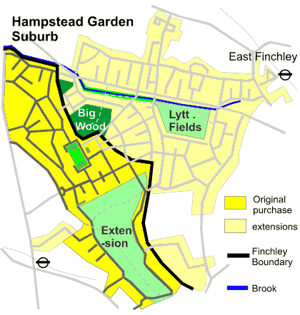
Before Central Square was complete the HGS Trust acquired from the Ecclesiastical
Commissioners a lease on land in neighbouring Finchley, stretching from here
down the hill to the Mutton Brook. This included Little and Big Woods, opened
to the public, although it would appear Big Wood was clipped to make way for
the fan-shaped extension of the formal layout eastwards.
The Co-Partners negotiated a lease on most of the remaining
rural land up the valley, to the Bishop’s Avenue and the houses on East
End Road. Subsequently the Trust sold many of its rights on the Finchley land
to the Co-Partners, including the right to use the name Hampstead Garden Suburb.
The relaxing of control and the increasingly commercial stance of the Co-Partners
meant that the Finchley part of the Suburb, the largest in area, lacks some
of the charm and individuality of the original.
After many battles the Suburb is now on a different footing. The complete story
is told by Mervyn Miller and A. Stuart Gray in their excellent book “Hampstead
Garden Suburb”
| Author | Title | Publisher | |
| Theo Barker | Moving Millions | London Transport Museum 1990 | A |
| Fred Davis | St Mary-at-Finchley | Barnet Libraries 1983 | C |
| Fred Davis | Finchley Common: a notorious place | Barnet Libraries 1981 | C |
| Fred Davis | Finchley Manor: influential families | Barnet Libraries 1982 | C |
| J Bryant, C Colson | The Landscape of Kenwood | English Heritage 1990 | C |
| Alan Farmer | Hampstead Heath | Historical Publications 1984 | B |
| Ken Gay | From Forest to Suburb | Hornsey Historical Society 1996 | C |
| Ken Gay | Palace on the Hill | Hornsey Historical Society 1992 | C |
| J Heathfield | Finchley & Whetstone Past | Historical Publications 2001 | B |
| M A C Horne | The Northern Line | Douglas Rose 1987 | C |
| C. W. Ikin | Hampstead Heath | High Hill Press | C |
| GRP Lawrence | Village into Borough | 1964 | B |
| Ian Murray | Haringey before our time | Hornsey Historical Society 1993 | C |
| M Miller and S Gray | Hampstead Garden Suburb | Phillimore & Co 1992 | B |
| Roy Porter | London A Social History | Hamish Hamilton 1994 | B |
| Malcolm Stokes | A Walk Along Ancient Boundaries in Kenwood | Hornsey Historical Society 1995 | C |
| Clive R Smith | Finchley As It Was | CR Smith/Hillary Press | C |
| David Sullivan | The Westminster Corridor | Historical Publications 1994 | B |
| British Geological Survey | London & the Thames Valley | 4th edition, HMSO 1996 | A |
| S Gillies, P Taylor | Finchley and Friern Barnet | Phillimore & Co 1992 | B |
| Jack Whitehead | The Growth of Muswell Hill | Jack Whitehead 1995 | A |
| Old Ordnance Survey Maps 1894/5:
Alexandra Park & South Friern, East Finchley, Hendon, Finchely &
Holders Hill, Kenwood & Golders Green, Highgate, Mid Finchley, Muswell
Hill Also 3rd edition, 1912: East Finchley & H.G.S. |
The Godfrey Edition (The backs of these maps contain much historical information) |
D | |
| Reprint of 1st edition of 1 inch Ordnance Survey Sheet 71 | David & Charles | D | |
| 1:50 000 Series E & W Sheet 256, North London | British Geological Survey 1994 | D | |
A: Paperback Book, B: Hardback Book, C: Booklet/Pamphlet, D: Map Some sources of publications: East Finchley Library, Muswell Hill Bookshop, Hampstead Museum (Burgh House), Church Farm House Museum (Hendon), Dillons Bookshop. Credit goes to The Finchley Society for most of the historical photos on this site. Note: This lists the key sources of information and inspiration which made the articles possible, and a deep debt of gratitude to the authors and publishers is acknowledged. Click here for on line access to Victoria County History Middlesex volume 6, the volume that covers Finchley and Friern Barnet, courtesy of British History Online. |
|||